
Why SDI for Smart Government?
Spatial Data Infrastructure (SDI) is vital for smart governance. It creates a strong framework to manage, share, and use geospatial data. This data is crucial for informed decisions and efficient service delivery.
Governments must ensure community well-being and support sustainable development goals. They also need to monitor the environment and promote green energy. In addition, they support the blue economy and develop policies that rely on spatially enabled information from various sectors.
Implementing SDI helps governments to:

- Spatial Data Collaboration and Sharing: Facilitate seamless collaboration and data sharing among various government departments and stakeholders, enhancing overall efficiency.
- Single Trough of Spatial Data Services: Create a unified platform for accessing all spatial data services, streamlining data retrieval and usage.
- Reduce Duplication of Spatial Data Custodians: Minimize redundancy in data management, ensuring that different departments do not duplicate efforts in maintaining similar datasets.
- Alignment and Collaboration in Spatial Data Projects: Ensure that spatial data projects are aligned and coordinated, preventing duplication and optimizing resource use.
- Build Geo-Enabled Solutions for Smart Government and Community Wellbeing: Develop solutions that leverage geospatial data to enhance public services and promote community well-being.
IST Contribution and Unique Value:
iSpatial Techno Solution (IST) brings a unique value proposition with its extensive experience in implementing SDI strategies and solutions, especially in the UAE and USA markets. Our contributions include:
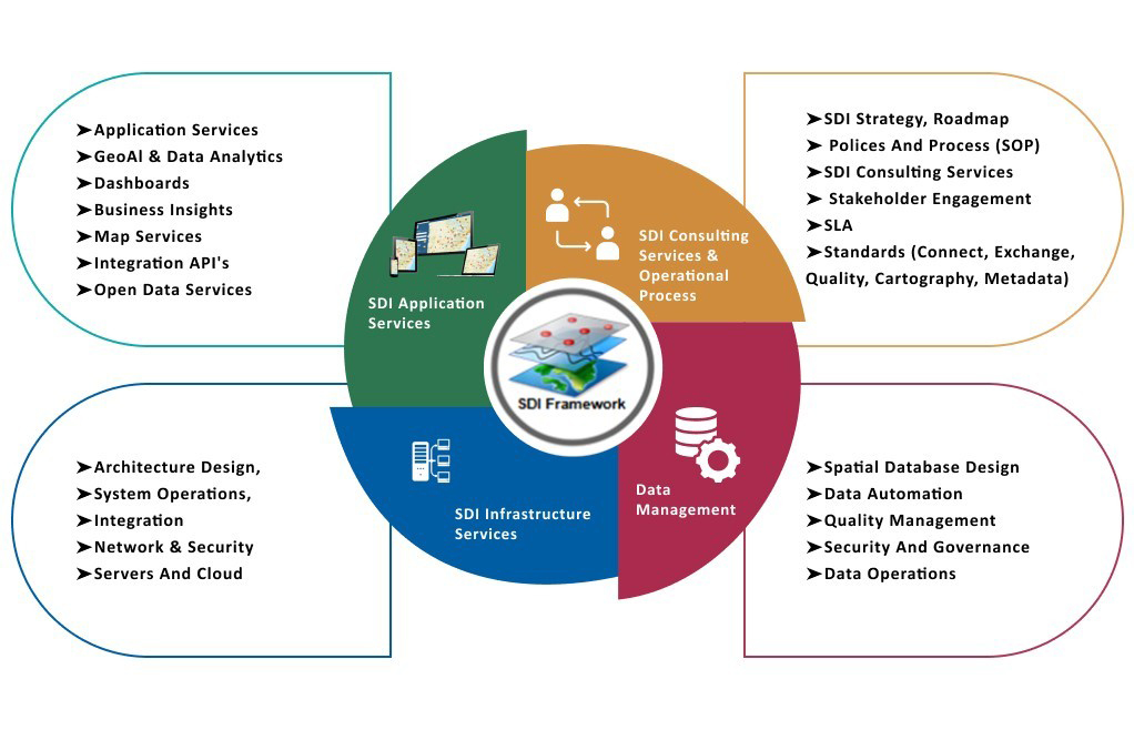
- SDI Framework Aligned with UNGGIM IGIF Pathways: IST's SDI framework not only addresses governance, technology, and people but also ensures comprehensive stakeholder engagement. Moreover, it includes service level agreements (SLA), outreach, and communication, making the SDI program more effective.
- Comprehensive Solutions: Our framework goes beyond just data management; it also focuses on spatial data automation and technology enablement. Furthermore, we integrate data, software, and infrastructure to deliver geo-smart services. In addition, we emphasize data standards, metadata, and standard operating procedures (SOPs) to ensure smooth operations and meet program objectives.
- Innovative Advancements: IST is now advancing SDI from Data to Intelligence by integrating Geo AI and LLM models with the Open AI platform. As a result, our MAPGPT platform provides easy access to both spatial and non-spatial information using natural language. This, in turn, enhances user experience and improves data accessibility.

Best Practices
To ensure the success of SDI implementations, we follow best practices including:
- IGIF Framework: To achieve a comprehensive SDI design and implementation, it is essential to adhere to the Integrated Geospatial Information Framework (IGIF).
- ISO Metadata Standards: In addition, ensuring compliance with metadata standards enhances data management and interoperability.
- Data Content Standards: Moreover, maintaining high-quality data content standards improves accuracy and reliability.
- Security: Implement robust security measures to protect data integrity and privacy.
- OGC Compliance: Follow Open Geospatial Consortium (OGC) standards for interoperability and compatibility with various systems.
Contact iSpatial Techno Solution (IST) to transform your data management and service delivery frameworks. Our innovative SDI solutions are designed to make your operations more efficient, and data driven.
Discover how we can help your organization achieve its goals by contacting us at connect us @ispatialtec.com. Let’s work together to harness the power of spatial data and drive your success.